Assam, with its extensive network of rivers, faces perennial challenges of floods and erosion, significantly hampering the state's development. The Brahmaputra and Barak rivers, fed by over 50 tributaries, unleash annual monsoon devastation.
This recurrent crisis is unique to Assam in its extent and duration, making it one of the most acutely affected regions in India.
The Rashtriya Barh Ayog (RBA) estimates that 31.05 lakh hectares of Assam's total 78.523 lakh hectares are flood-prone—approximately 39.58% of the state's total area.
This figure starkly contrasts with the national average, where the flood-prone area constitutes only about 10.2% of the country.
Assam's vulnerability to floods is thus four times the national average.
Historical context
Assam's post-independence history is punctuated by major floods in 1954, 1962, 1972, 1977, 1984, 1988, 1998, 2002, 2004, and 2012.
On average, three to four waves of floods ravage the state annually, affecting an average of 9.31 lakh hectares each year.
The financial toll is staggering, with average annual losses around Rs. 200 crores.
Notable catastrophic years include 1998 and 2004, with losses amounting to Rs. 500 crores and Rs. 771 crores, respectively.
Flash floods compounding the crisis
The situation is exacerbated by flash floods from rivers originating in Arunachal Pradesh and Meghalaya. In 2004 and 2014, flash floods of high magnitude struck the south bank tributaries of the Brahmaputra in lower Assam, triggered by cloudbursts in Meghalaya.
Similarly, in August 2011, cloudbursts in Arunachal Pradesh led to devastating flash floods in the Gainadi and Jiadhal rivers, causing extensive damage and loss of life.
Latest flood data
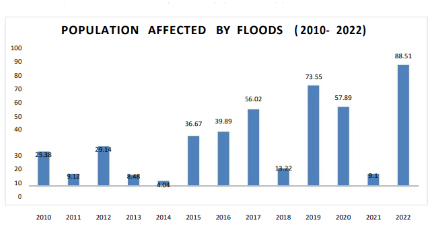
The impact of floods remains severe. In 2024 alone, 79 people have lost their lives, and over 24 lakh people have been affected.
According to the Assam State Disaster Management Authority, rivers like Brahmaputra (at Neamatighat, Tezpur, Guwahati, Dhubri), Burhidihing, Dikhou, Disang, Kopili, and Kushiayara continue to flow above danger levels despite some receding water levels.
The floods have also impacted over 25,000 animals and thousands of hectares of land.
Human and economic toll
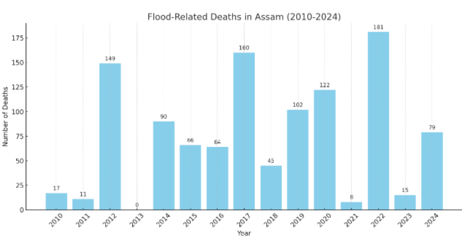
The human toll of floods in Assam is grim. A comparative overview of flood-related deaths from 2010 to 2024 reveals the following:
- 2010: 17 deaths
- 2011: 11 deaths
- 2012: 149 deaths
- 2013: 0 deaths
- 2014: 90 deaths
- 2015: 66 deaths
- 2016: 64 deaths
- 2017: 160 deaths
- 2018: 45 deaths
- 2019: 102 deaths
- 2020: 122 deaths
- 2021: 8 deaths
- 2022: 181 deaths
- 2023: 15 deaths
- 2024: 79 deaths so far
Erosion: The Silent devastator
Bank erosion by the Brahmaputra, Barak, and their tributaries is another significant issue. Since 1950, erosion has claimed over 4.27 lakh hectares of land—7.40% of Assam's total area.
The annual loss is nearly 8,000 hectares.
The Brahmaputra's width has increased to 15 km at certain points due to severe erosion, continuously altering the river's course and causing breaches in embankments.
This ongoing erosion reduces the state's fertile agricultural land, severely impacting the rural economy.
The unique geography and climate of Assam
Assam's geographic and climatic conditions contribute significantly to its flooding woes. The Brahmaputra, originating from the Tibetan plateau, brings increased water flow downstream due to rising temperatures and melting glaciers.
The river's sharp turn at Goalpara further exacerbates flooding. Human settlement and construction in floodplains obstruct the natural flow of water, compounding the problem.
The region's tropical monsoon rainforest climate ensures high rainfall and humidity, particularly from June to September due to the South-West monsoon. Traditional slash-and-burn (jhum) cultivation in hilly areas removes protective soil layers, increasing erosion and reducing water absorption.
The Brahmaputra, with its average width of 5.46 km and heavy siltation, is a natural flood-prone river.
Climate change has intensified these issues, with increased rainfall and flash floods reducing the river's water-carrying capacity.
The Embankment dilemma
Embankments, initially constructed in the 1960s to control floods, have become a double-edged sword.
Most embankments have either outlived their utility or are in poor condition.
Successive governments have spent over Rs. 30,000 crore on embankments over the past six decades, but these structures often fail, leading to inundation of houses and land.
Embankments have also encouraged encroachment on riverbanks, exacerbating flood risks.
Population pressure
The population boom in Assam has intensified ecological pressures. The Brahmaputra valley's population density increased from 9-29 people per sq. km. in 1940-41 to 398 per sq. km. in the plains by 2011.
This population surge has strained the state's resources and infrastructure, complicating flood management efforts.

